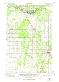
1956 Map of Karlstad
USGS Topo · Published 1976About this map
Karlstad and the surrounding townships of Deerwood and Norway are defined by a grid of agricultural drainage ditches and the diagonal route of the Minneapolis St Paul and Sault Ste Marie railroad. In the mid-1950s, this landscape shows a transition from the wooded Twistal Swamp to the organized fields of Kittson and Marshall Counties. The South Branch Two Rivers flows into Lake Bronson State Park, where a Gaging Station and Bible Camp Church sit near the water's edge. This period captures a network of rural institutions, from the East Emmaus Church to the Benson School, that supported a dispersed farming population. The map meticulously records the water management system essential to local agriculture, including County Ditch No 10 and State Ditch No 90, which reshaped the Red River Valley terrain.
Find a feature on this map
41 named features on this map. Tap any name to fly to it.
Don’t see what you’re looking for? This feature index may not catch every label — zoom into the map to look around manually.
Map Details
Editions of this 1956 Karlstad Map
2 editions found

Other maps of this area

1918 · Hemmington
USGS Topo · 1:62,500

1918 · Argyle
USGS Topo · 1:62,500

1919 · Pelan
USGS Topo · 1:62,500

1930 · Juneberry
USGS Topo · 1:31,680

1932 · Juneberry
USGS Topo · 1:62,500

1939 · Kennedy
USGS Topo · 1:62,500

1941 · Kennedy
USGS Topo · 1:62,500

1941 · Hallock
USGS Topo · 1:62,500

1952 · Thief River Falls
USGS Topo · 1:250,000

1954 · Stephen
USGS Topo · 1:62,500