
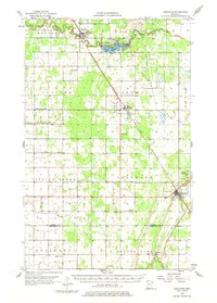
1956 Map of Karlstad
USGS Topo · Published 1958About this map
The Minneapolis St Paul and Sault Ste Marie railroad cuts a diagonal path through this corner of Kittson and Marshall Counties, anchoring the small prairie communities of Halma and Karlstad. This 1950s survey documents a landscape of structured townships like Jupiter and Spring Brook, where the rural social fabric is visible through landmarks such as Bepson Sch and several country churches, including East Emmaus Ch and Hegland Ch. To the north, the South Branch Two Rivers feeds into Lake Bronson, the centerpiece of Lake Bronson State Park. The terrain shifts from organized farmland to the wetlands of Twistal Swamp in the east, while the Tamarac River meanders through the southern townships. Local history is preserved in the location of several family and community burial grounds, such as Lundeby Cem and Eidsvold Cem.
Find a feature on this map
34 named features on this map. Tap any name to fly to it.
Don’t see what you’re looking for? This feature index may not catch every label — zoom into the map to look around manually.
Map Details
Editions of this 1956 Karlstad Map
2 editions found
Other maps of this area

1918 · Hemmington
USGS Topo · 1:62,500

1918 · Argyle
USGS Topo · 1:62,500

1919 · Pelan
USGS Topo · 1:62,500

1930 · Juneberry
USGS Topo · 1:31,680

1932 · Juneberry
USGS Topo · 1:62,500

1939 · Kennedy
USGS Topo · 1:62,500

1941 · Kennedy
USGS Topo · 1:62,500

1941 · Hallock
USGS Topo · 1:62,500

1952 · Thief River Falls
USGS Topo · 1:250,000

1954 · Stephen
USGS Topo · 1:62,500