
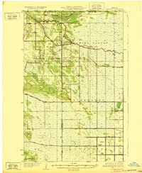
1932 Map of Juneberry
USGS Topo · Published 1932About this map
The Roseau River meanders across the international border in this early 1930s survey, marking a landscape defined by an extensive drainage system. Large-scale water management projects are evident through a network of engineered waterways, including State Ditch No 72, State Ditch No 69, and State Ditch No 95, which cut across the townships of Caribou, Blooming Valley, and Polonia. This infrastructure reflects the era's significant efforts to reclaim northern Minnesota wetlands for agricultural use.
Find a feature on this map
24 named features on this map. Tap any name to fly to it.
Don’t see what you’re looking for? This feature index may not catch every label — zoom into the map to look around manually.
Map Details
Editions of this 1932 Juneberry Map
2 editions found
Other maps of this area

1918 · Hemmington
USGS Topo · 1:62,500

1918 · Greenbush
USGS Topo · 1:62,500

1919 · Pelan
USGS Topo · 1:62,500

1919 · Badger
USGS Topo · 1:62,500

1930 · Juneberry
USGS Topo · 1:31,680

1952 · Thief River Falls
USGS Topo · 1:250,000

1956 · Thief River Falls
USGS Topo · 1:250,000

1956 · Karlstad
USGS Topo · 1:62,500

1957 · Thief River Falls
USGS Topo · 1:250,000

1957 · Pelan
USGS Topo · 1:62,500