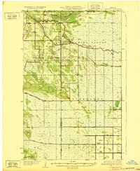
1932 Map of Juneberry
USGS Topo · Published 1932About this map
The Roseau River meanders across the northern border of this Minnesota landscape, marking the international boundary between the United States and Canada. This early twentieth-century survey, overseen by E. V. Willard of the Minnesota Department of Drainage and Waters, illustrates a sparsely populated borderland where settlement is concentrated at Caribou and Oak Point. The map reflects a highly managed hydraulic landscape, with numerous State Ditches etched across the terrain to facilitate drainage. These engineering efforts were critical to the development of the region during this era, attempting to transform the wetlands of the far north into viable agricultural or timber lands. The proximity to the Canadian border and the focus on river management make this a significant record of the rural infrastructure of the period.
Find a feature on this map
3 named features on this map. Tap any name to fly to it.
Don’t see what you’re looking for? This feature index may not catch every label — zoom into the map to look around manually.
Map Details
Editions of this 1932 Juneberry Map
2 editions found
Other maps of this area

1918 · Hemmington
USGS Topo · 1:62,500

1918 · Greenbush
USGS Topo · 1:62,500

1919 · Pelan
USGS Topo · 1:62,500

1919 · Badger
USGS Topo · 1:62,500

1930 · Juneberry
USGS Topo · 1:31,680

1932 · Juneberry
USGS Topo · 1:62,500

1952 · Thief River Falls
USGS Topo · 1:250,000

1956 · Thief River Falls
USGS Topo · 1:250,000

1956 · Karlstad
USGS Topo · 1:62,500

1957 · Thief River Falls
USGS Topo · 1:250,000