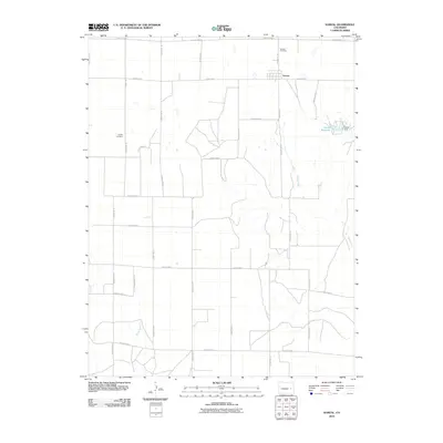
2010 Map of Karval
USGS Topo · Published 2010About this map
Karval stands as a distinct high-plains settlement in this 2010 survey of Lincoln County, where the grid of county roads meets the natural drainage of Adobe Creek. The town's layout is centered near Hodgson St, just south of County Road T. For those researching local family history, the map precisely locates both Bucklen Cemetery north of the main settlement and Dudley Cemetery to the west. The landscape is defined by its intermittent water sources and land management, featuring the Karval Reservoir and its associated Karval Dam. Further south, the terrain is marked by the winding path of Sand Arroyo, illustrating the transition from organized agricultural plotting to the natural arroyo systems of the Colorado plains.
Find a feature on this map
25 named features on this map. Tap any name to fly to it.
Don’t see what you’re looking for? This feature index may not catch every label — zoom into the map to look around manually.
Map Details
Editions of this 2010 Karval Map
This is the sole edition of this map. No revisions or reprints were ever made.
Other maps of this area

1889 · Sanborn
USGS Topo · 1:125,000

1891 · Sanborn
USGS Topo · 1:125,000

1891 · Arroyo
USGS Topo · 1:125,000

1893 · Arroyo
USGS Topo · 1:125,000

1893 · Sanborn
USGS Topo · 1:125,000

1954 · Lamar
USGS Topo · 1:250,000

1958 · Lamar
USGS Topo · 1:250,000

1975 · Stanley Gulch
USGS Topo · 1:24,000

1977 · Punkin Center
USGS Topo · 1:24,000
1978 · Metz Springs
USGS Topo · 1:24,000