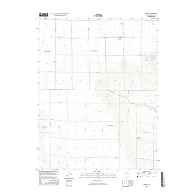
2016 Map of Karval
USGS Topo · Published 2016About this map
Karval serves as the primary settlement on this Lincoln County landscape, situated where the grid of county roads meets Kravig St. The terrain is defined by the drainage patterns of Adobe Creek and the southern Sand Arroyo, reflecting a region oriented around water management and rural life. Genealogy and local history are anchored by burial sites such as Bucklen Cem and Dudley Cem, as well as the specific Samuel Messersmith Grave located south of the main township. The presence of Karval Reservoir and infrastructure like Redwood Tank highlights the vital role of water storage in this high plains environment, where the land is carved into distinct sections by the Public Land Survey System as shown in t15s r55w and t16s r55w.
Find a feature on this map
31 named features on this map. Tap any name to fly to it.
Don’t see what you’re looking for? This feature index may not catch every label — zoom into the map to look around manually.
Map Details
Editions of this 2016 Karval Map
This is the sole edition of this map. No revisions or reprints were ever made.
Other maps of this area

1889 · Sanborn
USGS Topo · 1:125,000

1891 · Sanborn
USGS Topo · 1:125,000

1891 · Arroyo
USGS Topo · 1:125,000

1893 · Arroyo
USGS Topo · 1:125,000

1893 · Sanborn
USGS Topo · 1:125,000

1954 · Lamar
USGS Topo · 1:250,000

1958 · Lamar
USGS Topo · 1:250,000

1975 · Stanley Gulch
USGS Topo · 1:24,000

1977 · Punkin Center
USGS Topo · 1:24,000
1978 · Metz Springs
USGS Topo · 1:24,000