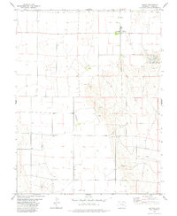
1978 Map of Karval
USGS Topo · Published 1978About this map
The high plains of eastern Lincoln County center on the small settlement of Karval, shown here in the late 1970s. This agricultural landscape is defined by the intermittent flow of Adobe Creek and a network of scattered wells and springs, vital for survival in this arid environment. Local landmarks include a Landing Strip and a quiet Ch in the town center, while the Karval Lake State Recreation Area provides a rare concentrated water feature and public space to the east.
Find a feature on this map
15 named features on this map. Tap any name to fly to it.
Don’t see what you’re looking for? This feature index may not catch every label — zoom into the map to look around manually.
Map Details
Editions of this 1978 Karval Map
This is the sole edition of this map. No revisions or reprints were ever made.
Other maps of this area

1889 · Sanborn
USGS Topo · 1:125,000

1891 · Sanborn
USGS Topo · 1:125,000

1891 · Arroyo
USGS Topo · 1:125,000

1893 · Arroyo
USGS Topo · 1:125,000

1893 · Sanborn
USGS Topo · 1:125,000

1954 · Lamar
USGS Topo · 1:250,000

1958 · Lamar
USGS Topo · 1:250,000

1975 · Stanley Gulch
USGS Topo · 1:24,000

1977 · Punkin Center
USGS Topo · 1:24,000
1978 · Metz Springs
USGS Topo · 1:24,000