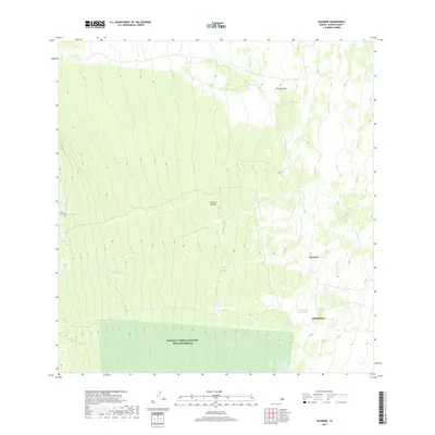
2017 Map of Kaunene
USGS Topo · Published 2017About this map
Hakalan Forest National Wildlife Refuge dominates the southern section of this 2017 survey on the Island of Hawaiʻi. The landscape is defined by its dramatic elevation changes and unique hydrological features, including the Kiʻilae Watercourse and the Komakawai Waterholes. These water sources are vital markers in a terrain otherwise characterized by steep volcanic slopes and ridges. The settlements of Komakawai and Kaunēnē appear as distinct focal points amidst the topography, connected to the western region by Brunner Rd. This map captures a specific moment in the management of the island's interior, showing the intersection of conservation lands and high-altitude landmarks like Puʻukinikini. The layout of these named points and water features offers insight into the way the land is navigated and protected in this portion of Hawaiʻi County.
Find a feature on this map
8 named features on this map. Tap any name to fly to it.
Don’t see what you’re looking for? This feature index may not catch every label — zoom into the map to look around manually.
Map Details
Editions of this 2017 Kaunene Map
This is the sole edition of this map. No revisions or reprints were ever made.
Other maps of this area

1927 · Kaohe
USGS Topo · 1:62,500

1928 · Kailua
USGS Topo · 1:62,500

1928 · Mauna Loa
USGS Topo · 1:62,500

1930 · Kaohe
USGS Topo · 1:62,500

1954 · Hawaii South
USGS Topo · 1:250,000

1954 · Hawaii North
USGS Topo · 1:250,000

1956 · Puu O Uo
USGS Topo · 1:24,000

1959 · Hawaii South
USGS Topo · 1:250,000

1959 · Hawaii North
USGS Topo · 1:250,000

1959 · Honaunau
USGS Topo · 1:24,000