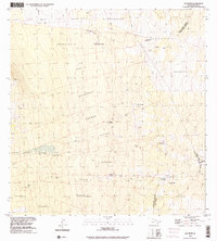
1993 Map of Kaunene
USGS Topo · Published 2001About this map
The upland slopes of the South Kona District are defined by a network of 4WD tracks and agricultural outposts in this 1993 study. Prominent landmarks such as Gaspars Dairy and remote habitations like Hapu'u Camp and Big Hill Camp appear among the traditional land divisions of Hōnaunau, Ki'ilae, and Ho'okena. The map details the water-scarce environment of the region, noting numerous isolated Water Tanks, the Komakawai Waterholes, and a Gaging Station located along the Ki'ilae Watercourse. Evidence of pastoral activity is visible in the form of a Corral and an extensive Rock Wall near the northern boundary. Peaks like Pu'ukinikini and Keanapa'akai punctuate the terrain, while the settlement at Kaunene sits high on the ridge line near the South Kona and North Kona District border.
Find a feature on this map
30 named features on this map. Tap any name to fly to it.
Don’t see what you’re looking for? This feature index may not catch every label — zoom into the map to look around manually.
Map Details
Editions of this 1993 Kaunene Map
This is the sole edition of this map. No revisions or reprints were ever made.
Other maps of this area

1927 · Kaohe
USGS Topo · 1:62,500

1928 · Kailua
USGS Topo · 1:62,500

1928 · Mauna Loa
USGS Topo · 1:62,500

1930 · Kaohe
USGS Topo · 1:62,500

1954 · Hawaii South
USGS Topo · 1:250,000

1954 · Hawaii North
USGS Topo · 1:250,000

1956 · Puu O Uo
USGS Topo · 1:24,000

1959 · Hawaii South
USGS Topo · 1:250,000

1959 · Hawaii North
USGS Topo · 1:250,000

1959 · Honaunau
USGS Topo · 1:24,000