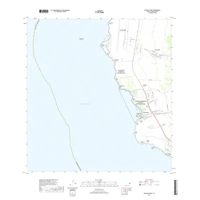
2017 Map of Keahole Point
USGS Topo · Published 2017About this map
Kalaoa sits atop the volcanic slopes of the Island of Hawai'i, overlooking a coast defined by ancient aquaculture and modern infrastructure. This 2017 survey details the maritime landscape where the Kona International Airport at Keahole occupies the flats of Keahole Point. To the south, the Kaloko-Honokōhau National Historical Park preserves vital indigenous engineering, including the Kaloko Fishpond and 'Alōpio Fishpond near Honokōhau Bay. These features demonstrate a long-standing relationship with the Pacific Ocean, where nearshore features like Makalawena Bank provided traditional fishing grounds. Inland, the expanding street networks around Kalaoa contrast with the rugged, preserved corridor of the Ala Kahakai National Historic Trail, which follows the shoreline through points like Wawahiwaa Point and Kāiwi Point. The map provides a look at the intersection of conservation lands and the developing North Kona region.
Find a feature on this map
55 named features on this map. Tap any name to fly to it.
Don’t see what you’re looking for? This feature index may not catch every label — zoom into the map to look around manually.
Map Details
Editions of this 2017 Keahole Point Map
This is the sole edition of this map. No revisions or reprints were ever made.
Other maps of this area

1928 · Puako
USGS Topo · 1:62,500

1928 · Kailua
USGS Topo · 1:62,500

1954 · Hawaii North
USGS Topo · 1:250,000

1959 · Hawaii North
USGS Topo · 1:250,000

1959 · Kiholo
USGS Topo · 1:24,000

1959 · Makalawena
USGS Topo · 1:24,000

1959 · Keahole Point
USGS Topo · 1:24,000

1959 · Kailua
USGS Topo · 1:24,000
1960 · Kealakekua
USGS Topo · 1:24,000

1961 · Hawaii North
USGS Topo · 1:250,000