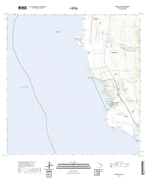
2024 Map of Keahole Point
USGS Topo · Published 2024About this map
Kaloko-Honokōhau National Historical Park dominates the central coastline of this West Hawaii landscape, preserving ancient Hawaiian cultural sites such as the Kaloko Fishpond. The map reveals a transition from traditional coastal trails like the Ala Kahiko Trl and Ala Mamalahoa Trl to modern aviation infrastructure at the Ellison Onizuka Kona International Airport at Keahole. Inland, the residential growth of Kaiminani and the northern edge of Kailua contrast with the rugged volcanic shoreline. Numerous points and beaches, including Keahole Point, Honokōhau Beach, and Alula Beach, define the interface between the Island of Hawai‘i and the Pacific Ocean. This survey illustrates the modern configuration of the Kona coast, where contemporary highway development meets historic fishing and settlement areas.
Find a feature on this map
61 named features on this map. Tap any name to fly to it.
Don’t see what you’re looking for? This feature index may not catch every label — zoom into the map to look around manually.
Map Details
Editions of this 2024 Keahole Point Map
This is the sole edition of this map. No revisions or reprints were ever made.
Other maps of this area

1928 · Puako
USGS Topo · 1:62,500

1928 · Kailua
USGS Topo · 1:62,500

1954 · Hawaii North
USGS Topo · 1:250,000

1959 · Hawaii North
USGS Topo · 1:250,000

1959 · Kiholo
USGS Topo · 1:24,000

1959 · Makalawena
USGS Topo · 1:24,000

1959 · Keahole Point
USGS Topo · 1:24,000

1959 · Kailua
USGS Topo · 1:24,000
1960 · Kealakekua
USGS Topo · 1:24,000

1961 · Hawaii North
USGS Topo · 1:250,000