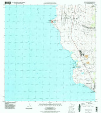
1996 Map of Keahole Point
USGS Topo · Published 1998About this map
The Lava Flow of 1801 dominates the coastal shelf of West Hawaii, a stark reminder of the volcanic activity that shaped this shoreline. This mid-1990s survey illustrates the intersection of ancient terrain and modern infrastructure, centered on the expansion of the Kona International Airport at Keahole. Inland, the agricultural and residential heritage of the region is evident in the sprawling Kalaoa-Ooma Homesteads and Honokohau Homesteads, where settlement patterns follow the higher elevations above the arid coast.
Find a feature on this map
57 named features on this map. Tap any name to fly to it.
Don’t see what you’re looking for? This feature index may not catch every label — zoom into the map to look around manually.
Map Details
Editions of this 1996 Keahole Point Map
This is the sole edition of this map. No revisions or reprints were ever made.
Other maps of this area

1928 · Puako
USGS Topo · 1:62,500

1928 · Kailua
USGS Topo · 1:62,500

1954 · Hawaii North
USGS Topo · 1:250,000

1959 · Hawaii North
USGS Topo · 1:250,000

1959 · Kiholo
USGS Topo · 1:24,000

1959 · Makalawena
USGS Topo · 1:24,000

1959 · Keahole Point
USGS Topo · 1:24,000

1959 · Kailua
USGS Topo · 1:24,000
1960 · Kealakekua
USGS Topo · 1:24,000

1961 · Hawaii North
USGS Topo · 1:250,000