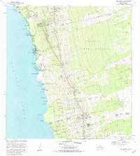
1982 Map of Kealakekua
USGS Topo · Published 1984About this map
The Kamehameha III Birthplace at Keahou Bay anchor this 1982 coastal survey of the Kona District, where ancient Hawaiian landmarks meet modern settlement patterns. Along the rugged volcanic shoreline, numerous sacred sites including Kauakaiaola Heiau, Kealakekua Heiau, and Papakohola Heiau are meticulously recorded, alongside the somber Burial Ground For Kuamoo Battle Warriors near Lekeleke Bay.
Find a feature on this map
82 named features on this map. Tap any name to fly to it.
Don’t see what you’re looking for? This feature index may not catch every label — zoom into the map to look around manually.
Map Details
Editions of this 1982 Kealakekua Map
2 editions found
Other maps of this area

1928 · Kailua
USGS Topo · 1:62,500

1954 · Hawaii South
USGS Topo · 1:250,000

1954 · Hawaii North
USGS Topo · 1:250,000

1959 · Hawaii South
USGS Topo · 1:250,000

1959 · Hawaii North
USGS Topo · 1:250,000

1959 · Hualalai
USGS Topo · 1:24,000

1959 · Honaunau
USGS Topo · 1:24,000

1959 · Puu Lehua
USGS Topo · 1:24,000

1959 · Keahole Point
USGS Topo · 1:24,000

1959 · Kailua
USGS Topo · 1:24,000