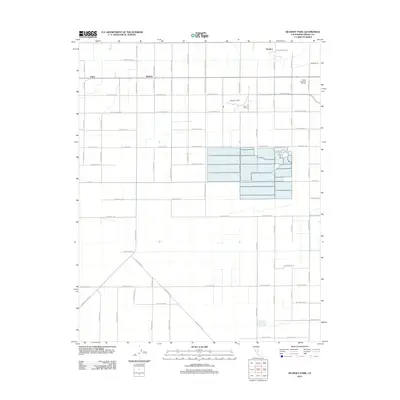
2012 Map of Kearney Park
USGS Topo · Published 2012About this map
The agrarian landscape of the San Joaquin Valley is defined here by a precise grid of roads and irrigation infrastructure west of Fresno. Kearney Park stands as a central landmark, its grounds and the palm-lined W Kearney Blvd providing a distinct contrast to the surrounding agricultural blocks. This 2012 survey illustrates the continued importance of water management in the region, seen in features like the Hawn Ditch which feeds the local fields. Small rural settlements and institutional sites are scattered throughout the territory, including Rolinda, Pratton, and Floyd. The map also identifies the Honor Farm and the sprawling grounds of Fresno Memorial Gardens, reflecting the diverse land use at the city's western edge where industrial agriculture meets community services.
Find a feature on this map
46 named features on this map. Tap any name to fly to it.
Don’t see what you’re looking for? This feature index may not catch every label — zoom into the map to look around manually.
Map Details
Editions of this 2012 Kearney Park Map
This is the sole edition of this map. No revisions or reprints were ever made.
Other maps of this area

1921 · Bullard
USGS Topo · 1:31,680

1923 · Kearney Park
USGS Topo · 1:31,680

1923 · Herndon
USGS Topo · 1:31,680

1923 · Fresno
USGS Topo · 1:31,680

1923 · Biola
USGS Topo · 1:31,680

1923 · Bullard
USGS Topo · 1:31,680

1925 · Helm
USGS Topo · 1:31,680

1925 · Raisin
USGS Topo · 1:31,680

1925 · Caruthers
USGS Topo · 1:31,680
1946 · Fresno South
USGS Topo · 1:24,000