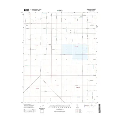
2015 Map of Kearney Park
USGS Topo · Published 2015About this map
San Joaquin Valley agriculture dominates this landscape west of Fresno, defined by a dense network of irrigation infrastructure and rural settlements. Small communities like Rolinda, Pratton, and Floyd are situated along a grid of section-line roads, with Kearney Park serving as a prominent landmark in the north-central portion of the map. The intricate water management system is the defining feature of the area, including the Little Houghton Canal, Houghton Canal, and several smaller ditches like Vogel Ditch and Garfield Ditch. The presence of the Fresno Colony Canal and Dry Cr Canal highlights the systematic reclamation and watering of this valley land for production. Genealogists may also find interest in the location of Fresno Memorial Gardens in the northeastern section of the quadrangle. Southward, the landscape transitions into drainage areas such as the Central Wasteway and Dickenson Waste, which manage runoff from the extensive field systems.
Find a feature on this map
66 named features on this map. Tap any name to fly to it.
Don’t see what you’re looking for? This feature index may not catch every label — zoom into the map to look around manually.
Map Details
Editions of this 2015 Kearney Park Map
This is the sole edition of this map. No revisions or reprints were ever made.
Other maps of this area

1921 · Bullard
USGS Topo · 1:31,680

1923 · Kearney Park
USGS Topo · 1:31,680

1923 · Herndon
USGS Topo · 1:31,680

1923 · Fresno
USGS Topo · 1:31,680

1923 · Biola
USGS Topo · 1:31,680

1923 · Bullard
USGS Topo · 1:31,680

1925 · Helm
USGS Topo · 1:31,680

1925 · Raisin
USGS Topo · 1:31,680

1925 · Caruthers
USGS Topo · 1:31,680
1946 · Fresno South
USGS Topo · 1:24,000