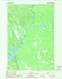
1988 Map of Kelleyland
USGS Topo · Published 1988About this map
The St. Croix River defines the international boundary between Maine and New Brunswick in this late 1980s topographical record. The settlement of Kelleyland sits just downstream from the Grand Falls Dam, where the river transitions from the wide Grand Falls Flowage into a narrower channel punctuated by Spednic Falls and Kendricks Rips. The landscape is characterized by a series of prominent elevations and ridges, including Pomeroy Ridge, Scotch Ridge, and Upper Little Ridge, which suggest a terrain shaped by glacial activity and drainage patterns like Meadow Brook. Local history markers are evident in the Cem near Hoodleys and the network of family-named landmarks such as Macs Hill and Gleason Pt. The map illustrates the sparsely populated borderland where industrial water management at Grand Falls meets the rural ridges of Baileyville.
Find a feature on this map
47 named features on this map. Tap any name to fly to it.
Don’t see what you’re looking for? This feature index may not catch every label — zoom into the map to look around manually.
Map Details
Editions of this 1988 Kelleyland Map
This is the sole edition of this map. No revisions or reprints were ever made.
Other maps of this area

1929 · Calais
USGS Topo · 1:48,000

1932 · Calais
USGS Topo · 1:62,500

1940 · Waite
USGS Topo · 1:62,500

1940 · Kellyland
USGS Topo · 1:62,500

1941 · Big Lake
USGS Topo · 1:62,500

1942 · Kellyland
USGS Topo · 1:62,500

1942 · Waite
USGS Topo · 1:62,500

1943 · Big Lake
USGS Topo · 1:62,500

1949 · Calais
USGS Topo · 1:24,000

1952 · Big Lake
USGS Topo · 1:50,000