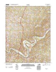
2013 Map of Kelly
USGS Topo · Published 2013About this map
The James River snakes through the southern portion of this landscape, separating the industrial and historical sites of Mount Athos and Oxford Furnace from the residential expansion of Madison Heights. The terrain is characterized by its relationship to the water, where the river's path is marked by features like the Ninemile Bridge, Joshua Falls, and river islands such as Feagans Island. Away from the riverbank, the land rises toward Galts Mill Mountain and Chestnut Mountain, where older mill sites like Brightwell Mill and Galts Mill sit along the drainage of Beck Cr. Residential clusters such as City Gomingo, Sandy Bottom, and Viking Fiord illustrate the suburban development patterns north of Colony. The presence of several named shops, including Martins Shop and Wright Shop, alongside the private Falwell Airport, indicates a mix of local commerce and private aviation infrastructure in this part of Amherst County.
Find a feature on this map
214 named features on this map. Tap any name to fly to it.
Don’t see what you’re looking for? This feature index may not catch every label — zoom into the map to look around manually.
Map Details
Editions of this 2013 Kelly Map
This is the sole edition of this map. No revisions or reprints were ever made.
Other maps of this area

1892 · Lynchburg
USGS Topo · 1:125,000

1892 · Buckingham
USGS Topo · 1:125,000

1892 · Appomattox
USGS Topo · 1:125,000

1894 · Lexington
USGS Topo · 1:125,000

1935 · Amherst
USGS Topo · 1:48,000

1939 · Amherst
USGS Topo · 1:62,500

1944 · Lynchburg
USGS Topo · 1:62,500

1947 · Roanoke
USGS Topo · 1:250,000

1950 · Amherst
USGS Topo · 1:62,500

1950 · Lynchburg
USGS Topo · 1:62,500