
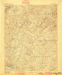
1892 Map of Appomattox
USGS Topo · Published 1892About this map
The Grave of Patrick Henry sits near the southern edge of this late nineteenth-century landscape, a quiet testament to the region's deep historical roots along the Staunton River. This 1892 edition captures a dense network of small communities and rural outposts across Appomattox and neighboring counties before the automobile reshaped the Piedmont. The central role of rail transportation is evident, as the Norfolk and Western Railroad anchors the growth of Pamplin City and Evergreen, while the Lynchburg and Durham Railroad cuts through the western edge of Campbell county. River crossings like Beazleys Ford and Venabels Bridge on the Appomattox River highlight the vital, localized infrastructure of the era. The terrain is marked by family names and community centers such as Morris Church, Rose Bower, and Darlington Heights, reflecting a highly localized social geography typical of the post-Reconstruction South.
Find a feature on this map
100 named features on this map. Tap any name to fly to it.
Don’t see what you’re looking for? This feature index may not catch every label — zoom into the map to look around manually.
Map Details
Editions of this 1892 Appomattox Map
6 editions found




Other maps of this area

1891 · Palmyra
USGS Topo · 1:125,000

1891 · Farmville
USGS Topo · 1:125,000

1892 · Lynchburg
USGS Topo · 1:125,000

1892 · Buckingham
USGS Topo · 1:125,000

1893 · Farmville
USGS Topo · 1:125,000

1894 · Lexington
USGS Topo · 1:125,000

1895 · Palmyra
USGS Topo · 1:125,000

1897 · Palmyra
USGS Topo · 1:125,000

1935 · Amherst
USGS Topo · 1:48,000

1939 · Amherst
USGS Topo · 1:62,500