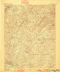
1892 Map of Appomattox
USGS Topo · Published 1901About this map
Staunton River and James River frontage define this late nineteenth-century survey of the Virginia heartland, spanning the borders of seven counties. This period of Virginia's development is marked by a complex network of river-and-rail commerce, with the Norfolk and Western Railroad and the Richmond and Danville R. R. cutting across the agricultural landscape. Near the southern edge of the map, the Grave of Patrick Henry serves as a significant landmark at the edge of the Halifax county line. The interior is dotted with localized commercial hubs and rural service points such as Wyatt Shop, Pamplin City, and Red House. Transportation relies heavily on established crossings like Venables Bridge and Beazleys Ford, while dozens of creeks and branches weave between prominent peaks like Piney Mt. and Pilot Mt..
Find a feature on this map
77 named features on this map. Tap any name to fly to it.
Don’t see what you’re looking for? This feature index may not catch every label — zoom into the map to look around manually.
Map Details
Editions of this 1892 Appomattox Map
6 editions found



Other maps of this area

1891 · Palmyra
USGS Topo · 1:125,000

1891 · Farmville
USGS Topo · 1:125,000

1892 · Lynchburg
USGS Topo · 1:125,000

1892 · Buckingham
USGS Topo · 1:125,000

1892 · Appomattox
USGS Topo · 1:125,000

1893 · Farmville
USGS Topo · 1:125,000

1894 · Lexington
USGS Topo · 1:125,000

1895 · Palmyra
USGS Topo · 1:125,000

1897 · Palmyra
USGS Topo · 1:125,000

1935 · Amherst
USGS Topo · 1:48,000