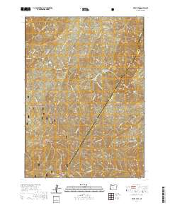
2020 Map of Kelsey Peak
USGS Topo · Published 2020About this map
The Rogue Wild and Scenic River carves a deep path through the Siskiyou National Forest, serving as the primary geographical focus for this Josephine County survey. Along the river's winding course, distinct gravel bars and riverfront landings such as Missouri Bar, Winkle Bar, and Battle Bar define the historical human presence in this steep terrain. The presence of the Winkle Bar Airport highlights the unique transportation challenges of this corridor, where access often depends on small airstrips or winding forest routes like the Mule Creek-Marial Rd. Elevated features like Kelsey Peak and the Bald Ridge overlook a complex network of drainages, including Mule Cr and Jenny Cr. This landscape remains largely undeveloped, characterized by its system of Bureau of Land Management roads and the high-elevation open space of Big Meadows near the northern boundary.
Find a feature on this map
38 named features on this map. Tap any name to fly to it.
Don’t see what you’re looking for? This feature index may not catch every label — zoom into the map to look around manually.
Map Details
Editions of this 2020 Kelsey Peak Map
This is the sole edition of this map. No revisions or reprints were ever made.
Other maps of this area

1946 · Galice
USGS Topo · 1:62,500

1946 · Dutchman Butte
USGS Topo · 1:62,500

1948 · Galice
USGS Topo · 1:62,500

1948 · Dutchman Butte
USGS Topo · 1:62,500

1954 · Bone Mountain
USGS Topo · 1:62,500

1954 · Marial
USGS Topo · 1:62,500

1955 · Medford
USGS Topo · 1:250,000

1957 · Medford
USGS Topo · 1:250,000

1958 · Medford
USGS Topo · 1:250,000
1989 · Hobson Horn
USGS Topo · 1:24,000