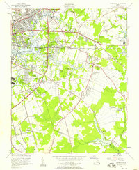
1955 Map of Kempsville
USGS Topo · Published 1958About this map
Broad Creek and the Elizabeth River Eastern Branch define this landscape as it appeared in the mid-1950s, a period of transition between the traditional rural landscape of Princess Anne Co and the expanding infrastructure of the City of Norfolk. The map reveals a fascinating mix of land uses, from the Glen Rock Airfield and a Speedway (Aban'd) near Thomas Corner to the City of Norfolk Waterworks and the City of Norfolk Welfare Center. Small truck-farming era settlements like Kempsville, Greenwich, and Acredale are interspersed with emerging residential developments such as Eastbrook Park and River Forest Shores. The spiritual and communal life of the region is evident in the many scattered landmarks, including Old Donation Ch, Old St Matthews Ch, and the Rosewood Memorial Cemetery, while the Norfolk Southern railroad tracks and major routes like Virginia Beach Boulevard provide the framework for the area's rapid post-war growth.
Find a feature on this map
92 named features on this map. Tap any name to fly to it.
Don’t see what you’re looking for? This feature index may not catch every label — zoom into the map to look around manually.
Map Details
Editions of this 1955 Kempsville Map
This is the sole edition of this map. No revisions or reprints were ever made.
Other maps of this area

1907 · Norfolk
USGS Topo · 1:125,000

1918 · Cape Henry
USGS Topo · 1:62,500

1919 · Cape Henry
USGS Topo · 1:62,500

1921 · Newport News
USGS Topo · 1:62,500

1939 · Moyock
USGS Topo · 1:62,500

1940 · Lake Drummond
USGS Topo · 1:62,500

1944 · Norfolk South
USGS Topo · 1:25,000

1945 · Lake Drummond
USGS Topo · 1:62,500

1946 · Moyock
USGS Topo · 1:62,500

1948 · Norfolk South
USGS Topo · 1:24,000