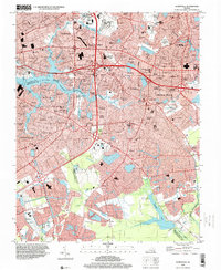
1994 Map of Kempsville
USGS Topo · Published 2000About this map
The Eastern Branch Elizabeth River and the winding Broad Creek define the western reaches of this Tidewater landscape, where the municipal boundaries of Norfolk, Virginia Beach, and Chesapeake converge. By the mid-1990s, suburban expansion had transformed former farmland into dense residential enclaves such as Aragona Village, Fairlawn Estates, and Kempsville Gardens. This transition is particularly evident near Interchange 284, where the complex highway network meets the established community of Glen Rock.
Find a feature on this map
133 named features on this map. Tap any name to fly to it.
Don’t see what you’re looking for? This feature index may not catch every label — zoom into the map to look around manually.
Map Details
Editions of this 1994 Kempsville Map
This is the sole edition of this map. No revisions or reprints were ever made.
Other maps of this area

1907 · Norfolk
USGS Topo · 1:125,000

1918 · Cape Henry
USGS Topo · 1:62,500

1919 · Cape Henry
USGS Topo · 1:62,500

1921 · Newport News
USGS Topo · 1:62,500

1939 · Moyock
USGS Topo · 1:62,500

1940 · Lake Drummond
USGS Topo · 1:62,500

1944 · Norfolk South
USGS Topo · 1:25,000

1945 · Lake Drummond
USGS Topo · 1:62,500

1946 · Moyock
USGS Topo · 1:62,500

1948 · Norfolk South
USGS Topo · 1:24,000