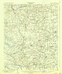
1903 Map of Kenly
USGS Topo · Published 1935About this map
Kenly and its surrounding coastal plain communities are defined here by a dense network of crossroads and agricultural infrastructure at the opening of the twentieth century. This survey, conducted in 1902, captures a landscape in transition where the Atlantic Coast Line and Southern R. R. railroads provide the primary corridors for trade, connecting towns like Micro and Pine Level to the wider region. The terrain is a complex assembly of drainage systems including Contentnea Creek, Little River, and the Nahunta Swamp, which dictated the placement of early industry such as Hornes Mill. Local history is deeply etched into the place names, from family-owned landmarks like Barnes Store and Moores Crossroads to educational hubs like Academy Crossroads. The map provides a precise record of late-Victorian era settlement patterns before the advent of modern highways reshaped these rural North Carolina townships.
Find a feature on this map
57 named features on this map. Tap any name to fly to it.
Don’t see what you’re looking for? This feature index may not catch every label — zoom into the map to look around manually.
Map Details
Editions of this 1903 Kenly Map
2 editions found
Other maps of this area

1902 · Kenly
USGS Topo · 1:62,500

1902 · Rocky Mount
USGS Topo · 1:62,500

1902 · Spring Hope
USGS Topo · 1:62,500

1903 · Kenly
USGS Topo · 1:62,500

1904 · Rocky Mount
USGS Topo · 1:62,500

1904 · Springhope
USGS Topo · 1:62,500

1904 · Wilson
USGS Topo · 1:62,500

1906 · Four Oaks
USGS Topo · 1:48,000

1908 · Four Oaks
USGS Topo · 1:62,500

1953 · Rocky Mount
USGS Topo · 1:250,000