1902 Map of Kenly
USGS Topo · Published 1957About this map
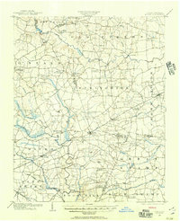
The rail-driven growth of the Coastal Plain is evident in this landscape, where the Atlantic Coast Line and Southern R. R. anchor a network of small agricultural hubs. Communities like Kenly, Micro, and Pine Level follow the iron corridors, while the surrounding countryside is defined by an intricate web of "crossroads" settlements such as Moores Crossroads, Buckhorn Crossroads, and Hares Crossroads. These named intersections point to the importance of early overland travel and local commerce at places like Barnes Store.
Find a feature on this map
60 named features on this map. Tap any name to fly to it.
Don’t see what you’re looking for? This feature index may not catch every label — zoom into the map to look around manually.
Map Details
Editions of this 1902 Kenly Map
2 editions found
Other maps of this area

1902 · Kenly
USGS Topo · 1:62,500

1902 · Rocky Mount
USGS Topo · 1:62,500

1902 · Spring Hope
USGS Topo · 1:62,500

1903 · Kenly
USGS Topo · 1:62,500

1904 · Rocky Mount
USGS Topo · 1:62,500

1904 · Springhope
USGS Topo · 1:62,500

1904 · Wilson
USGS Topo · 1:62,500

1906 · Four Oaks
USGS Topo · 1:48,000

1908 · Four Oaks
USGS Topo · 1:62,500

1953 · Rocky Mount
USGS Topo · 1:250,000