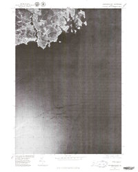
1975 Map of Kennebunkport
USGS Topo · Published 1979About this map
Kennebunkport and the nearby village of Cape Porpoise are the focal points of this mid-1970s orthophotograph, which captures the Maine coastline through direct aerial imagery. Unlike a conventional topographic map, this survey uses rectified photography taken on April 30, 1975, to show the precise density of coastal development and the texture of the rocky shore. The settlement at Coopers Corner sits just inland from the winding River, while the residential sprawl around Turbats Creek reflects the area's mid-century growth. The image provides a rare view of the docks, harbor structures, and maritime layout before modern renovations, extending out into the Atlantic Ocean and encompassing the neighbor town of Kennebunk.
Find a feature on this map
7 named features on this map. Tap any name to fly to it.
Don’t see what you’re looking for? This feature index may not catch every label — zoom into the map to look around manually.
Map Details
Editions of this 1975 Kennebunkport Map
This is the sole edition of this map. No revisions or reprints were ever made.
Other maps of this area

1891 · Biddeford
USGS Topo · 1:62,500

1891 · Kennebunk
USGS Topo · 1:62,500

1893 · Kennebunk
USGS Topo · 1:62,500

1893 · York
USGS Topo · 1:62,500

1893 · Biddeford
USGS Topo · 1:62,500

1898 · Kennebunk
USGS Topo · 1:62,500

1920 · York
USGS Topo · 1:62,500

1941 · Biddeford
USGS Topo · 1:62,500

1941 · Kennebunk
USGS Topo · 1:62,500

1944 · Wells
USGS Topo · 1:24,000