2023 Map of Kennedy
USGS Topo · Published 2023About this map
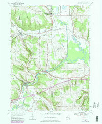
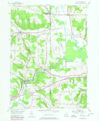
Conewango Creek defines the valley floor of this Chautauqua and Cattaraugus County borderland, winding through a landscape shaped by glacial deposits and colonial-era settlement patterns. The village of Kennedy serves as a central hub, while the surrounding upland ridges like Bentley Hill and Mutton Hill are bisected by a network of drainage systems including Allen Brook and Twentyeighth Creek. These small watercourses historically supported local mills and agriculture, a legacy still visible in the scattered distribution of rural settlements like Ellington and Poland Center.
Find a feature on this map
90 named features on this map. Tap any name to fly to it.
Don’t see what you’re looking for? This feature index may not catch every label — zoom into the map to look around manually.
Map Details
Editions of this 2023 Kennedy Map
This is the sole edition of this map. No revisions or reprints were ever made.
Historical Maps of Clear Creek Through Time
3 maps found