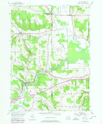
1979 Map of Kennedy
USGS Topo · Published 1980About this map
Conewango Creek meanders through the heart of this landscape, defining the rural character of the Chautauqua and Cattaraugus county line during the late 1970s. The village of Kennedy serves as a primary hub, situated where the waterway meets the Conrail line and several prominent roads like Wheelock Road. This era shows a community deeply connected by its smaller hamlets and crossroads, including Schermerhorn Corners and Poland Center.
Find a feature on this map
62 named features on this map. Tap any name to fly to it.
Don’t see what you’re looking for? This feature index may not catch every label — zoom into the map to look around manually.
Map Details
Editions of this 1979 Kennedy Map
This is the sole edition of this map. No revisions or reprints were ever made.
Other maps of this area

1900 · Cherry Creek
USGS Topo · 1:62,500

1905 · Jamestown
USGS Topo · 1:62,500

1922 · Randolph
USGS Topo · 1:62,500

1923 · Randolph
USGS Topo · 1:62,500

1923 · Cattaraugus
USGS Topo · 1:62,500

1938 · Cattaraugus
USGS Topo · 1:62,500

1941 · Cattaraugus
USGS Topo · 1:62,500

1941 · Cherry Creek
USGS Topo · 1:62,500

1942 · Jamestown
USGS Topo · 1:62,500

1943 · Randolph
USGS Topo · 1:62,500