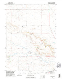
1990 Map of Kessler Gap
USGS Topo · Published 1995About this map
Bear Mountain and the prominent formation of Castle Rocks anchor this high-plains landscape in Goshen County during the 1990s. The map reveals an intricate system of water management and natural drainage, characterized by the Kessler Ditch and Lovercheck Ditch which parallel the flows of Bear Creek and Lovercheck Creek. These irrigation features, alongside a remote Landing Strip, indicate a specialized ranching or agricultural economy adapted to the high-elevation terrain near Kessler Gap. The presence of several named water sources, including Kessler Spring and other unnamed springs, suggests the critical importance of water rights and access in this arid environment. Collectors and genealogists can trace the physical geography of the Kessler and Atterberry canyons, while landmarks like Squaw Rock provide specific points of reference within the vast county line area.
Find a feature on this map
19 named features on this map. Tap any name to fly to it.
Don’t see what you’re looking for? This feature index may not catch every label — zoom into the map to look around manually.
Map Details
Editions of this 1990 Kessler Gap Map
This is the sole edition of this map. No revisions or reprints were ever made.
Other maps of this area

1899 · Goshen Hole
USGS Topo · 1:125,000

1954 · Cheyenne
USGS Topo · 1:250,000

1958 · Cheyenne
USGS Topo · 1:250,000

1960 · Diamond Flat
USGS Topo · 1:24,000

1960 · Petsch Reservoir
USGS Topo · 1:24,000

1960 · Hawk Springs
USGS Topo · 1:24,000

1960 · Needle Rock
USGS Topo · 1:24,000

1960 · Rocky Hollow
USGS Topo · 1:24,000

1960 · Kessler Gap
USGS Topo · 1:24,000

1960 · Meriden
USGS Topo · 1:24,000