1960 Map of Kessler Gap
USGS Topo · Published 1962About this map
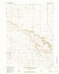
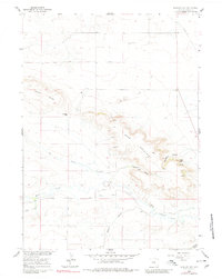
Bear Mountain dominates this high-plains landscape in southeastern Wyoming, where the dramatic formations of Castle Rocks and Squaw Rock rise above the surrounding terrain. Recorded in 1960, the map illustrates an intricate system of water management vital to this ranching country, featuring the Kessler Ditch, Bear Creek Ditch, and Lovercheck Ditch. These man-made channels diverge from natural watercourses like Fox Creek and Bear Creek to support the arid land.
Find a feature on this map
17 named features on this map. Tap any name to fly to it.
Don’t see what you’re looking for? This feature index may not catch every label — zoom into the map to look around manually.
Map Details
Editions of this 1960 Kessler Gap Map
3 editions found
Historical Maps of Goshen County Through Time
89 maps found

1896 Patrick
Goshen County, WY

1899 Goshen Hole
Goshen County, WY

1950 Casebier Hill
Goshen County, WY

1950 Rockeagle
Goshen County, WY

1951 Moore Spring
Goshen County, WY

1960 Barnes
Goshen County, WY

1960 Cottier
Goshen County, WY

1960 Diamond Flat
Goshen County, WY

1960 Duroc
Goshen County, WY

1960 Habig Spring
Goshen County, WY

1960 Kessler Gap
Goshen County, WY

1960 Mc Compsey Pass
Goshen County, WY

1960 Needle Rock
Goshen County, WY

1960 Robb Draw
Goshen County, WY

1963 Carpenter Ranch
Goshen County, WY

1963 Cattail Ranch NE
Goshen County, WY

1963 Glomill Reservoir
Goshen County, WY

1963 Tea Kettle Rock
Goshen County, WY

1963 Torrington SE
Goshen County, WY

1963 Y B O Canyon
Goshen County, WY

1968 Glomill Reservoir
Goshen County, WY

1974 Jay Em
Goshen County, WY

1974 Jay Em NW
Goshen County, WY

1974 Rawhide Buttes East
Goshen County, WY

1974 Spoon Butte
Goshen County, WY

1974 Spoon Butte SW
Goshen County, WY

1977 Hileman Draw
Goshen County, WY

1977 Prairie Center
Goshen County, WY

1977 Red Cloud Creek East
Goshen County, WY

1977 Red Cloud Creek West
Goshen County, WY

1977 Spoon Butte NW
Goshen County, WY

1977 Van Tassell SE
Goshen County, WY

1978 Lone Sand Hill
Goshen County, WY

1978 Rawhide Buttes West
Goshen County, WY

1990 Barnes
Goshen County, WY

1990 Casebier Hill
Goshen County, WY

1990 Cattail Ranch NE
Goshen County, WY

1990 Cottier
Goshen County, WY

1990 Diamond Flat
Goshen County, WY

1990 Doty Hill
Goshen County, WY

1990 Duroc
Goshen County, WY

1990 Glomill Reservoir
Goshen County, WY

1990 Habig Spring
Goshen County, WY

1990 Jay Em
Goshen County, WY

1990 Jay Em NW
Goshen County, WY

1990 Kessler Gap
Goshen County, WY

1990 Lone Sand Hill
Goshen County, WY

1990 Mc Compsey Pass
Goshen County, WY

1990 Moore Spring
Goshen County, WY

1990 Needle Rock
Goshen County, WY

1990 Red Cloud Creek East
Goshen County, WY

1990 Red Cloud Creek West
Goshen County, WY

1990 Robb Draw
Goshen County, WY

1990 Spoon Butte
Goshen County, WY

1990 Spoon Butte NW
Goshen County, WY

1990 Spoon Butte SW
Goshen County, WY

1990 Tea Kettle Rock
Goshen County, WY

1990 Torrington SE
Goshen County, WY

1990 Y B O Canyon
Goshen County, WY

2021 Barnes
Goshen County, WY

2021 Casebier Hill
Goshen County, WY

2021 Cattail Ranch NE
Goshen County, WY

2021 Cottier
Goshen County, WY

2021 Diamond Flat
Goshen County, WY

2021 Doty Hill
Goshen County, WY

2021 Duroc
Goshen County, WY

2021 Glomill Reservoir
Goshen County, WY

2021 Habig Spring
Goshen County, WY

2021 Hileman Draw
Goshen County, WY

2021 Jay Em
Goshen County, WY

2021 Jay Em NW
Goshen County, WY

2021 Lone Sand Hill
Goshen County, WY

2021 McCompsey Pass
Goshen County, WY

2021 Moore Spring
Goshen County, WY

2021 Needle Rock
Goshen County, WY

2021 Prairie Center
Goshen County, WY

2021 Rawhide Buttes East
Goshen County, WY

2021 Rawhide Buttes West
Goshen County, WY

2021 Red Cloud Creek East
Goshen County, WY

2021 Red Cloud Creek West
Goshen County, WY

2021 Robb Draw
Goshen County, WY

2021 Spoon Butte
Goshen County, WY

2021 Spoon Butte NW
Goshen County, WY

2021 Spoon Butte SW
Goshen County, WY

2021 Tea Kettle Rock
Goshen County, WY

2021 Torrington SE
Goshen County, WY

2021 Van Tassell SE
Goshen County, WY

2021 Y B O Canyon
Goshen County, WY

2023 Kessler Gap
Goshen County, WY