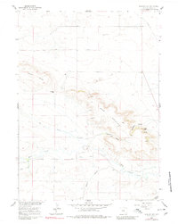
1960 Map of Kessler Gap
USGS Topo · Published 1980About this map
Bear Mountain dominates this portion of Goshen County, its rugged escarpments defining a landscape of high ridges and deep drainages. In the late 1950s and early 1960s, the agricultural footprint of the region was tied to a complex network of irrigation channels, including the Kessler Ditch, Bear Creek Ditch, and Lovercheck Ditch, which directed water from Fox Creek and Bear Creek across the lower elevations. These features reflect the intensive water management required for ranching and farming in the Wyoming basin. Geological landmarks like Castle Rocks and Kessler Gap provide distinct navigational points, while family-named features such as Atterberry Canyon and Lovercheck Canyon suggest the local heritage of the homesteading families who settled the surrounding range. The presence of Sand Dunes north of the mountain highlights the diverse geomorphology found within this high-plains environment.
Find a feature on this map
15 named features on this map. Tap any name to fly to it.
Don’t see what you’re looking for? This feature index may not catch every label — zoom into the map to look around manually.
Map Details
Editions of this 1960 Kessler Gap Map
3 editions found
Other maps of this area

1899 · Goshen Hole
USGS Topo · 1:125,000

1954 · Cheyenne
USGS Topo · 1:250,000

1958 · Cheyenne
USGS Topo · 1:250,000

1960 · Diamond Flat
USGS Topo · 1:24,000

1960 · Petsch Reservoir
USGS Topo · 1:24,000

1960 · Hawk Springs
USGS Topo · 1:24,000

1960 · Needle Rock
USGS Topo · 1:24,000

1960 · Rocky Hollow
USGS Topo · 1:24,000

1960 · Kessler Gap
USGS Topo · 1:24,000

1960 · Meriden
USGS Topo · 1:24,000