
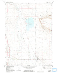
1960 Map of La Grange
USGS Topo · Published 1962About this map
Horse Creek and Bear Creek converge near the settlement of La Grange in this 1960s study of Goshen County. The landscape is defined by the critical management of water in a high-plains environment, evidenced by the extensive network of the Hawk Springs Ditch and Wycross Ditch feeding into the Hawk Springs Reservoir. The Union Pacific railroad corridor runs northwest-southeast, providing a vital transportation link for the ranching operations that anchor the local economy, such as the Wycross Ranch and C P Ranch. To the east, the dramatic rising terrain of Sixtysix Mountain is etched with numerous named drainages including Walker Canyon and Nichols Canyon, contrasting with the irrigated valley floor. Genealogists will find the La Grange Cem situated just east of the main townsite, marking the established roots of this agricultural community.
Find a feature on this map
25 named features on this map. Tap any name to fly to it.
Don’t see what you’re looking for? This feature index may not catch every label — zoom into the map to look around manually.
Map Details
Editions of this 1960 La Grange Map
2 editions found
Other maps of this area

1899 · Goshen Hole
USGS Topo · 1:125,000

1954 · Cheyenne
USGS Topo · 1:250,000

1958 · Cheyenne
USGS Topo · 1:250,000

1960 · Tremain
USGS Topo · 1:24,000

1960 · Mc Compsey Pass
USGS Topo · 1:24,000

1960 · Petsch Reservoir
USGS Topo · 1:24,000

1960 · Hawk Springs
USGS Topo · 1:24,000

1960 · Kessler Gap
USGS Topo · 1:24,000

1960 · Meriden
USGS Topo · 1:24,000
1960 · Duroc
USGS Topo · 1:24,000