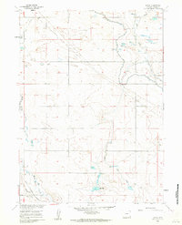
1960 Map of Duroc
USGS Topo · Published 1962About this map
Duroc marks the center of this Wyoming high plains landscape, surveyed in the late 1950s as part of a Department of the Interior program for the development of the Missouri River Basin. The region is defined by its sophisticated irrigation and water management infrastructure, most notably the Fort Laramie Canal and the smaller Ditch systems that divert water across the plains. Large natural and man-made water features like Horse Creek, Mc Millan Reservoir, and Little Willow Res punctuate the arid terrain. Transportation and logistics are anchored by the Union Pacific railroad, which cuts through the southwestern corner of the sheet, providing a critical link for the agricultural and ranching operations that relied on these water sources. The map also traces a network of unnamed pipelines and scattered Well sites, illustrating the industrial expansion into the eastern Goshen County landscape.
Find a feature on this map
13 named features on this map. Tap any name to fly to it.
Don’t see what you’re looking for? This feature index may not catch every label — zoom into the map to look around manually.
Map Details
Editions of this 1960 Duroc Map
3 editions found
Other maps of this area

1899 · Goshen Hole
USGS Topo · 1:125,000

1954 · Cheyenne
USGS Topo · 1:250,000

1958 · Cheyenne
USGS Topo · 1:250,000

1960 · Huntley
USGS Topo · 1:24,000

1960 · Mc Compsey Pass
USGS Topo · 1:24,000

1960 · Hawk Springs
USGS Topo · 1:24,000

1960 · Lyman
USGS Topo · 1:24,000

1960 · Kessler Gap
USGS Topo · 1:24,000

1960 · La Grange
USGS Topo · 1:24,000
1960 · Robb Draw
USGS Topo · 1:24,000