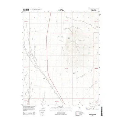
2014 Map of Keyhole Canyon
USGS Topo · Published 2014About this map
Eldorado Valley dominates the southwestern portion of this desert landscape, where the alluvial fans of the Mojave Desert meet the dry lake beds. The map provides a high-resolution view of the terrain east of Highway 95, where the mountain slopes are cut by deep washes, most notably Keyhole Canyon. This area is characterized by its isolation and dramatic elevation changes, punctuated by infrequent water sources such as Water Plug Number Two Spring. Local infrastructure is represented by desert tracks including Nelson Cutoff Rd and the evocatively named Grandpa's Rd, which navigate the transition from the flat valley floor to the rising rocky outcrops. The map illustrates the fundamental desert hydrology where seasonal runoff patterns shape the land long before reaching the valley bottom.
Find a feature on this map
16 named features on this map. Tap any name to fly to it.
Don’t see what you’re looking for? This feature index may not catch every label — zoom into the map to look around manually.
Map Details
Editions of this 2014 Keyhole Canyon Map
This is the sole edition of this map. No revisions or reprints were ever made.
Other maps of this area

1886 · Camp Mohave
USGS Topo · 1:250,000

1892 · Camp Mohave
USGS Topo · 1:250,000

1910 · Ivanpah
USGS Topo · 1:250,000

1912 · Ivanpah
USGS Topo · 1:250,000

1926 · Nelson
USGS Topo · 1:96,000

1942 · Camp Mohave
USGS Topo · 1:250,000

1942 · Ivanpah
USGS Topo · 1:250,000

1947 · Kingman
USGS Topo · 1:250,000

1948 · Kingman
USGS Topo · 1:250,000

1954 · Kingman
USGS Topo · 1:250,000