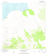
1959 Map of Kiholo
USGS Topo · Published 1970About this map
The Kaupulehu Lava Flow dominates this coastal landscape along the North Kona district of the island of Hawaii. Recorded during a 1959 field check, the map illustrates a rugged volcanic terrain shaped by historic events like the Lava Flow of 1859 and the Lava Flow of 1801. Near the shoreline, small oases of activity appear at Kiholo Bay and Luahinawai, where springs and waterholes supported life amidst the basalt.
Find a feature on this map
46 named features on this map. Tap any name to fly to it.
Don’t see what you’re looking for? This feature index may not catch every label — zoom into the map to look around manually.
Map Details
Editions of this 1959 Kiholo Map
2 editions found
Other maps of this area

1928 · Puako
USGS Topo · 1:62,500

1928 · Kailua
USGS Topo · 1:62,500

1954 · Hawaii North
USGS Topo · 1:250,000

1956 · Puu Hinai
USGS Topo · 1:24,000

1959 · Hawaii North
USGS Topo · 1:250,000

1959 · Kiholo
USGS Topo · 1:24,000

1959 · Hualalai
USGS Topo · 1:24,000
1959 · Anaehoomalu
USGS Topo · 1:24,000

1959 · Makalawena
USGS Topo · 1:24,000

1959 · Keahole Point
USGS Topo · 1:24,000