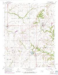
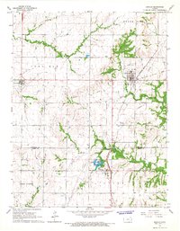
1966 Map of Kincaid
USGS Topo · Published 1983About this map
Kincaid stands as a central rail hub in the mid-1960s, defined by its position along the Missouri - Kansas - Texas Railroad. This landscape on the border of Anderson and Allen counties shows a transition from structured town grids to the winding riparian corridors of the Little Osage River and Deer Creek. The map documents a rural economy supported by energy extraction, evidenced by several Oil Wells and a Gas Well, while the community of Mildred is anchored by its proximity to Mildred Lake and a local Landing Strip. Local genealogy is well-preserved through detailed markers for the Kincaid Cem, Mt Zion Cem, and Lone Elm Cem. The presence of the Fairview Chapel further south suggests the dispersed nature of country congregations during this era, while the numerous quarries along the rail lines highlight the area's industrial foundations.
Find a feature on this map
26 named features on this map. Tap any name to fly to it.
Don’t see what you’re looking for? This feature index may not catch every label — zoom into the map to look around manually.
Map Details
Editions of this 1966 Kincaid Map
2 editions found
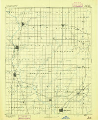
Other maps of this area

1885 · Garnett
USGS Topo · 1:125,000

1886 · Iola
USGS Topo · 1:125,000
1893 · Iola
USGS Topo · 1:125,000

1894 · Garnett
USGS Topo · 1:125,000

1904 · Iola
USGS Topo · 1:125,000

1947 · Lawrence
USGS Topo · 1:250,000

1947 · Joplin
USGS Topo · 1:250,000

1949 · Joplin
USGS Topo · 1:250,000

1950 · Lawrence
USGS Topo · 1:250,000

1954 · Joplin
USGS Topo · 1:250,000