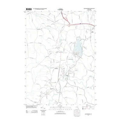
2013 Map of Kinderhook
USGS Topo · Published 2013About this map
Kinderhook and the village of Valatie anchor this landscape where the Kinderhook Cr and Valatie Kill converge. The area retains a strong agricultural character, defined by extensive orchard operations such as Samascott Orchard, Golden Harvest Farms, and Yonder Fruit Farms. These commercial agricultural holdings, along with Brosen Farm And Greenhouses, suggest a landscape still deeply tied to New York's historic fruit-growing traditions. Residential patterns are concentrated around the water at Niverville on Kinderhook Lake and the smaller settlement of Muitzes Kill to the northwest. For those tracing local families, several established burial grounds are marked, including Prospect Hill Cem, Kinderhook Cem, and Valatie Cem. The presence of the Berkshire Spur W and various county routes illustrates the modern transportation network that facilitates the region's cider and produce economy.
Find a feature on this map
150 named features on this map. Tap any name to fly to it.
Don’t see what you’re looking for? This feature index may not catch every label — zoom into the map to look around manually.
Map Details
Editions of this 2013 Kinderhook Map
This is the sole edition of this map. No revisions or reprints were ever made.
Other maps of this area

1893 · Troy
USGS Topo · 1:62,500

1893 · Coxsackie
USGS Topo · 1:62,500

1893 · Albany
USGS Topo · 1:62,500

1894 · Coxsackie
USGS Topo · 1:62,500

1895 · Troy
USGS Topo · 1:62,500

1895 · Albany
USGS Topo · 1:62,500

1898 · Albany
USGS Topo · 1:62,500

1898 · Troy
USGS Topo · 1:62,500

1903 · Kinderhook
USGS Topo · 1:62,500

1925 · Troy
USGS Topo · 1:48,000