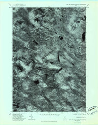
1977 Map of King and Bartlett Mountain
USGS Topo · Published 1983About this map
King and Bartlett Lake and the surrounding high timberlands of Somerset County are documented here through an orthophotographic perspective from the late 1970s. The landscape is defined by the sharp elevations of Spotted Spruce Mountain and King and Bartlett Mountain, separated by a drainage network that includes Kibby Stream and Spencer Stream. This aerial view emphasizes the dense forest cover and natural hydrological patterns before more modern logging developments altered the visible surface. Notable water bodies such as Jim Pond and Little Jim Pond sit in the lower elevations, while Camera Ridge and Farm Hill provide distinct topographic landmarks. The map records the raw, unpopulated state of the Maine woods during this era, showing only the natural features and watercourses like Butler Brook as they existed in 1977.
Find a feature on this map
10 named features on this map. Tap any name to fly to it.
Don’t see what you’re looking for? This feature index may not catch every label — zoom into the map to look around manually.
Map Details
Editions of this 1977 King and Bartlett Mountain Map
This is the sole edition of this map. No revisions or reprints were ever made.
Other maps of this area

1928 · Chain Lakes
USGS Topo · 1:48,000

1928 · Spencer
USGS Topo · 1:48,000

1928 · Stratton
USGS Topo · 1:48,000

1932 · Stratton
USGS Topo · 1:62,500

1932 · Kennebago Lake
USGS Topo · 1:48,000

1932 · Spencer
USGS Topo · 1:62,500

1932 · Chain Lakes
USGS Topo · 1:62,500

1935 · Kennebago Lake
USGS Topo · 1:62,500

1935 · Chain Lakes
USGS Topo · 1:62,500

1936 · Kennebago Lake
USGS Topo · 1:62,500
Featured Places
- Flagstaff Township, ME
- Haynestown Township, ME
- Kibby Township, ME
- Jim Pond Township, ME
- King & Bartlett Township, ME