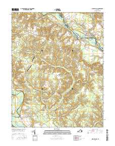
2016 Map of King William
USGS Topo · Published 2016About this map
The Mattaponi River serves as the primary boundary and transportation corridor in this portion of King William County, with the historic Walkerton Bridge connecting the community of Walkerton to the northern bank. The landscape is defined by the transition from riverfront settlements like Whitebank and Whitehall to the higher agricultural ground where Rumford and King William are situated. Small private airfields, including Hunt Airport and Brooklyn Airport, are scattered among the timbered swamps and tributaries that feed the major rivers.
Find a feature on this map
79 named features on this map. Tap any name to fly to it.
Don’t see what you’re looking for? This feature index may not catch every label — zoom into the map to look around manually.
Map Details
Editions of this 2016 King William Map
This is the sole edition of this map. No revisions or reprints were ever made.
Other maps of this area

1918 · Tappahannock
USGS Topo · 1:62,500

1918 · Aylett
USGS Topo · 1:62,500

1919 · New Kent
USGS Topo · 1:62,500

1919 · Tappahannock
USGS Topo · 1:62,500

1920 · King William
USGS Topo · 1:62,500

1933 · Aylett
USGS Topo · 1:62,500

1943 · Richmond
USGS Topo · 1:250,000
1944 · Howertons
USGS Topo · 1:24,000
1945 · Howertons
USGS Topo · 1:31,680
1949 · King William
USGS Topo · 1:24,000