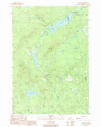
1989 Map of Kingsbury
USGS Topo · Published 1989About this map
Kingsbury Pond and the surrounding highlands of Kingsbury Plt and Brighton Plt dominate this 1980s landscape, where drainage patterns define the settlement of the Maine interior. The map captures a region of significant hydrological diversity, with large bogs such as Whitman Bog and Wellington Bog feeding into water bodies like Mayfield Pond and Wyman Pond. Human activity is concentrated along the arterial roads, marked by small hubs like Mayfield Corner and the village of Kingsbury, which is situated near Kingsbury Stream. The terrain is characterized by prominent elevations including Foss Mtn and Whittier Hill, while industrial traces appear in the form of a Gravel Pit near the northern shore of the pond. This survey offers a detailed view of the borderlands between Somerset and Piscataquis counties before modern developments altered these rural townships.
Find a feature on this map
40 named features on this map. Tap any name to fly to it.
Don’t see what you’re looking for? This feature index may not catch every label — zoom into the map to look around manually.
Map Details
Editions of this 1989 Kingsbury Map
This is the sole edition of this map. No revisions or reprints were ever made.
Other maps of this area

1903 · Bingham
USGS Topo · 1:62,500

1904 · Anson
USGS Topo · 1:62,500

1905 · Bingham
USGS Topo · 1:62,500

1913 · Skowhegan
USGS Topo · 1:62,500

1948 · Bangor
USGS Topo · 1:250,000

1948 · Kingsbury
USGS Topo · 1:62,500

1950 · Kingsbury
USGS Topo · 1:62,500

1954 · Millinocket
USGS Topo · 1:250,000

1955 · Anson
USGS Topo · 1:62,500

1955 · Skowhegan
USGS Topo · 1:62,500