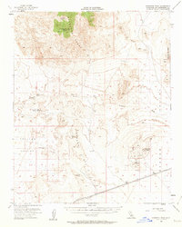
1955 Map of Kingston Peak
USGS Topo · Published 1963About this map
The high desert of San Bernardino County is defined by the Kingston Range and the Shadow Mountains, where the landscape is marked by the presence of mineral extraction and scarce water sources. Prospectors and miners established claims throughout this terrain, as evidenced by the Eastern Star Mine and the Shadow Mtn Mine, which sit alongside numerous scattered prospects and shafts. This mid-century survey documents the critical infrastructure of the era, from the desert outposts at Valley Wells to the isolated water points of Coyote Holes, Kingston Spring, and Porcupine Tank. The vast Valjean Valley and the prominent Kingston Peak provide a topographical frame for the network of unimproved roads and washes, including the significant Kingston Wash, which served as the primary transit corridors for those navigating this interior desert region.
Find a feature on this map
23 named features on this map. Tap any name to fly to it.
Don’t see what you’re looking for? This feature index may not catch every label — zoom into the map to look around manually.
Map Details
Editions of this 1955 Kingston Peak Map
3 editions found

Other maps of this area

1910 · Ivanpah
USGS Topo · 1:250,000

1912 · Ivanpah
USGS Topo · 1:250,000

1933 · Avawatz Mountains
USGS Topo · 1:250,000

1942 · Ivanpah
USGS Topo · 1:250,000

1947 · Trona
USGS Topo · 1:250,000

1947 · Kingman
USGS Topo · 1:250,000

1948 · Kingman
USGS Topo · 1:250,000

1948 · Trona
USGS Topo · 1:250,000

1950 · Tecopa
USGS Topo · 1:62,500

1951 · Tecopa
USGS Topo · 1:62,500