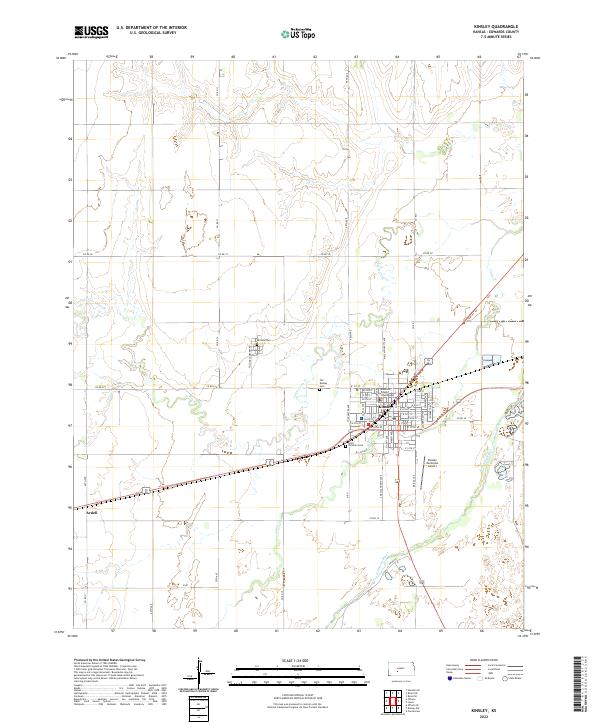
2022 Map of Kinsley
USGS Topo · Published 2022About this map
Kinsley serves as the focal point of this Edwards County landscape, where the historic Edwards County Courthouse stands at the center of a grid-iron street plan. The town's development is closely tied to its position along the Arkansas River, which flows through the southern portion of the sheet. The surrounding plains are marked by a network of drainage ways including Coon Cr and Little Coon Cr, while the settlement of Ardell sits to the west along the primary east-west highway corridor. Genealogy researchers will find significant value in the detailed plotting of several burial grounds, including Hillside Cem, Old Kinsley Cem, and Saint Nicholas Cem, each reflecting the community's early settlement patterns. Beyond the residential core, the Kinsley Municipal Airport and a vast network of section roads like 90th Ave and Co Rd 13 illustrate the modern agricultural and transport infrastructure of the region.
Find a feature on this map
56 named features on this map. Tap any name to fly to it.
Don’t see what you’re looking for? This feature index may not catch every label — zoom into the map to look around manually.
Map Details
Editions of this 2022 Kinsley Map
This is the sole edition of this map. No revisions or reprints were ever made.
Historical Maps of Ardell Through Time
6 maps found