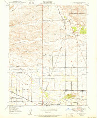
1950 Map of Kirkwood
USGS Topo · Published 1950About this map
The Southern Pacific railroad corridor defines the development of this agricultural landscape along the Tehama and Glenn county line. Near the settlement of Kirkwood, the land is marked by early burial grounds like Kirkwood Cem, while further south near Orland, the community's civic footprint is established through the Union High Sch and the Masonic Cem. This 1950 record shows a rural economy heavily reliant on managed water, evidenced by the extensive Stony Creek Irrigation Canal and its accompanying Stony Creek Irrigation Road. The map provides a look at mid-century aviation infrastructure, featuring both an Airway Beacon and the Orland Auxiliary Airport No 2. Numerous local schools, including Lake School, Calumet Sch, and the Seventh-day Adventist School, suggest a well-distributed rural population organized around established creek drainages like Hambright Creek and Stony Creek.
Find a feature on this map
26 named features on this map. Tap any name to fly to it.
Don’t see what you’re looking for? This feature index may not catch every label — zoom into the map to look around manually.
Map Details
Editions of this 1950 Kirkwood Map
This is the sole edition of this map. No revisions or reprints were ever made.
Other maps of this area

1904 · Vina
USGS Topo · 1:62,500

1904 · Walker Creek
USGS Topo · 1:31,680

1906 · Willows
USGS Topo · 1:62,500

1914 · Kirkwood
USGS Topo · 1:31,680

1914 · Orland
USGS Topo · 1:31,680

1914 · Hamilton
USGS Topo · 1:31,680

1914 · McIntosh Landing
USGS Topo · 1:31,680

1919 · Fruto
USGS Topo · 1:62,500

1944 · Fruto
USGS Topo · 1:62,500

1944 · Flournoy
USGS Topo · 1:62,500