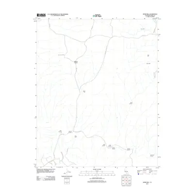
2012 Map of Knob Hill
USGS Topo · Published 2012About this map
The Mount Poso Oil Field dominates the northwest portion of this Kern County landscape, reflecting the region's enduring industrial character during the early 21st century. Settlement is sparse, anchored by the Halfway House located along Granite Rd. The terrain is defined by a series of drainages and notable geological formations such as Mon Bluff and Chalk Cliff, which rise above the surrounding canyons. Water management is evident through the Poso Canal and Cannell Way in the northeast, while Poso Cr meanders through the central and southern sections. This survey provides a clear look at the network of canyons, including Hillvale Canyon, Adobe Canyon, and Coffee Canyon, as they converge toward the lower elevations. The map documents the primary transportation arteries like the Bakersfield-Glennville Rd, which connects these remote resource-rich areas to larger population centers.
Find a feature on this map
31 named features on this map. Tap any name to fly to it.
Don’t see what you’re looking for? This feature index may not catch every label — zoom into the map to look around manually.
Map Details
Editions of this 2012 Knob Hill Map
This is the sole edition of this map. No revisions or reprints were ever made.
Other maps of this area

1906 · Bakersfield
USGS Topo · 1:62,500

1910 · Buena Vista Lake
USGS Topo · 1:125,000

1912 · Buena Vista Lake
USGS Topo · 1:125,000

1914 · Caliente
USGS Topo · 1:125,000

1930 · Oildale
USGS Topo · 1:31,680

1931 · Deepwell Ranch
USGS Topo · 1:31,680

1932 · North of Oildale
USGS Topo · 1:31,680

1932 · Woody
USGS Topo · 1:62,500
1933 · Oil Center
USGS Topo · 1:31,680

1935 · Woody
USGS Topo · 1:62,500