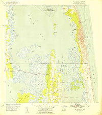
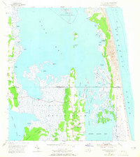
1954 Map of Knotts Island
USGS Topo · Published 1956About this map
The border of Virginia and North Carolina bisects this mid-century maritime landscape, where the secluded settlement of Knotts Island is anchored between the Back Bay and the Atlantic Ocean. This 1954 revision details a region defined by complex aquatic channels and expansive marshes, such as the Great Marsh and Fruitville area. Accessible via a prominent Causeway crossing from the west, the island community features the Knotts Island Church and several local cemeteries, serving as a vital hub in a territory shared between Princess Anne and Currituck counties.
Find a feature on this map
52 named features on this map. Tap any name to fly to it.
Don’t see what you’re looking for? This feature index may not catch every label — zoom into the map to look around manually.
Map Details
Editions of this 1954 Knotts Island Map
3 editions found

Other maps of this area

1893 · Virginia Beach
USGS Topo · 1:125,000

1916 · Back Bay
USGS Topo · 1:62,500

1939 · Moyock
USGS Topo · 1:62,500

1940 · Barco
USGS Topo · 1:62,500

1943 · Back Bay
USGS Topo · 1:62,500

1946 · Moyock
USGS Topo · 1:62,500

1946 · Eastville
USGS Topo · 1:250,000

1946 · Currituck Sound
USGS Topo · 1:250,000

1948 · Elizabeth City
USGS Topo · 1:62,500

1953 · Norfolk
USGS Topo · 1:250,000