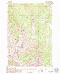
1988 Map of Koch Peak
USGS Topo · Published 1989About this map
Koch Peak and the surrounding Taylor Peaks dominate this high-elevation mountain terrain within the Lee Metcalf Wilderness. Located along the boundary between the Beaverhead National Forest and the Gallatin National Forest, the map records a landscape defined by sharp ridges and deep drainage basins in the 1980s. A network of creeks, including Indian Creek, Taylor Creek, and the curiously named Raw Liver Creek, flow through these steep elevations. Notable landmarks such as The Wedge and Sawtooth Ridge emphasize the dramatic vertical relief of the Madison Range. Small alpine water bodies like No Man Lake and Snake Lake are tucked into the high cirques, accessible only by a single 4wd track and wilderness trails, illustrating the area's enduring status as a protected primitive landscape.
Find a feature on this map
29 named features on this map. Tap any name to fly to it.
Don’t see what you’re looking for? This feature index may not catch every label — zoom into the map to look around manually.
Map Details
Editions of this 1988 Koch Peak Map
This is the sole edition of this map. No revisions or reprints were ever made.
Other maps of this area

1888 · Three Forks
USGS Topo · 1:250,000

1894 · Three Forks
USGS Topo · 1:250,000

1895 · Three Forks
USGS Topo · 1:250,000

1947 · Bozeman
USGS Topo · 1:250,000

1948 · Bozeman
USGS Topo · 1:250,000

1950 · Cliff Lake
USGS Topo · 1:62,500

1950 · Hebgen Dam
USGS Topo · 1:62,500

1950 · Cameron
USGS Topo · 1:62,500

1950 · Sphinx Mountain
USGS Topo · 1:62,500

1955 · Bozeman
USGS Topo · 1:250,000