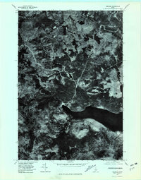
1977 Map of Kokadjo
USGS Topo · Published 1981About this map
Kokadjo sits at the head of First Roach Pond in this 1970s orthophotograph, serving as a gateway to the deep woods of northern Maine. The map reveals a dense network of logging roads and trails carved through heavy forest, illustrating the timber industry's footprint on the landscape during the late twentieth century. Unlike a standard topographic sheet, this imagery-based map provides a literal view of the vegetation density and clearings surrounding the Roach River and Siras Hill. Numerous watercourses including Jewett Brook, Tom Stream, and Lazy River drain into the primary pond, highlighting the complex hydrology that historically supported both log driving and backwoods recreation. The transition from the settled cluster at Kokadjo to the wilder reaches of Lagoon Brook captures the dual nature of this Piscataquis County outpost.
Find a feature on this map
8 named features on this map. Tap any name to fly to it.
Don’t see what you’re looking for? This feature index may not catch every label — zoom into the map to look around manually.
Map Details
Editions of this 1977 Kokadjo Map
This is the sole edition of this map. No revisions or reprints were ever made.
Other maps of this area

1920 · Moosehead Lake
USGS Topo · 1:62,500

1922 · Moosehead Lake
USGS Topo · 1:62,500

1930 · Moosehead Lake
USGS Topo · 1:62,500

1944 · Moosehead Lake
USGS Topo · 1:62,500

1952 · First Roach Pond
USGS Topo · 1:62,500

1954 · North East Carry
USGS Topo · 1:62,500

1954 · Grant Farm
USGS Topo · 1:62,500

1954 · Millinocket
USGS Topo · 1:250,000

1957 · Moosehead Lake
USGS Topo · 1:62,500

1958 · Millinocket
USGS Topo · 1:250,000
Featured Places
- Spencer Bay Township, ME
- Lily Bay Township, ME
- East Middlesex Canal Grant Township, ME
- T1 R13 WELS, ME
- Frenchtown Township, ME