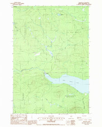
1988 Map of Kokadjo
USGS Topo · Published 1988About this map
Kokadjo sits as the primary settlement in this northern Maine landscape, positioned at the critical junction where the Roach River flows out from First Roach Pond. A prominent Dam at this outlet indicates the historical management of these waterways for the region's logging or hydroelectric needs. The map detail reveals a complex network of brooks and streams, including Lazy Tom Stream and Bear Brook, which drain the timberlands of Frenchtown and the Spencer Bay township.
Find a feature on this map
21 named features on this map. Tap any name to fly to it.
Don’t see what you’re looking for? This feature index may not catch every label — zoom into the map to look around manually.
Map Details
Editions of this 1988 Kokadjo Map
This is the sole edition of this map. No revisions or reprints were ever made.
Other maps of this area

1920 · Moosehead Lake
USGS Topo · 1:62,500

1922 · Moosehead Lake
USGS Topo · 1:62,500

1930 · Moosehead Lake
USGS Topo · 1:62,500

1944 · Moosehead Lake
USGS Topo · 1:62,500

1952 · First Roach Pond
USGS Topo · 1:62,500

1954 · North East Carry
USGS Topo · 1:62,500

1954 · Grant Farm
USGS Topo · 1:62,500

1954 · Millinocket
USGS Topo · 1:250,000

1957 · Moosehead Lake
USGS Topo · 1:62,500

1958 · Millinocket
USGS Topo · 1:250,000
Featured Places
- Spencer Bay Township, ME
- Lily Bay Township, ME
- East Middlesex Canal Grant Township, ME
- T1 R13 WELS, ME
- Frenchtown Township, ME