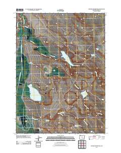
2011 Map of Krumbo Reservoir
USGS Topo · Published 2011About this map
Donner und Blitzen River winds along the western edge of this High Desert landscape, where water management defines the human footprint. The quadrangle is characterized by an extensive network of irrigation and storage features, including the Krumbo Canal, Warm Springs Canal, and the Eastside Canal. These systems support local operations like Witzel Ranch and Hilbert Ranch, while natural and man-made basins such as Baca Lake and Krumbo Reservoir serve as critical water sources in a region marked by names like the Dust Bowl and Dutch Oven. Further south, smaller catchments like Larkspur Reservoir and Lower Road Reservoir dot the drainage of Webb Spring Creek, illustrating the detailed hydrological planning required for ranching in this part of Harney County.
Find a feature on this map
27 named features on this map. Tap any name to fly to it.
Don’t see what you’re looking for? This feature index may not catch every label — zoom into the map to look around manually.
Map Details
Editions of this 2011 Krumbo Reservoir Map
This is the sole edition of this map. No revisions or reprints were ever made.
Other maps of this area

1955 · Burns
USGS Topo · 1:250,000

1955 · Adel
USGS Topo · 1:250,000

1957 · Adel
USGS Topo · 1:250,000

1958 · Burns
USGS Topo · 1:250,000

1958 · Adel
USGS Topo · 1:250,000

1959 · Burns
USGS Topo · 1:250,000

1962 · Adel
USGS Topo · 1:250,000

1967 · Krumbo Reservoir
USGS Topo · 1:24,000

1967 · Jackass Butte
USGS Topo · 1:24,000

1967 · Frenchglen
USGS Topo · 1:24,000