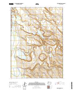
2020 Map of Krumbo Reservoir
USGS Topo · Published 2020About this map
Blitzen Valley defines the western edge of this Harney County landscape, where the Donner und Blitzen River and human-engineered water systems like the Krumbo Canal and Wamp Springs Canal manage the flow of water across the high desert. The map illustrates a complex network of reservoirs and springs essential to this arid environment, ranging from the prominent Krumbo Reservoir to smaller basins like De Witzel Reservoir and Larkspur Reservoir. High points and distinctive terrain features such as Krumbo Butte and the curious Dutch Oven rise above the flats. Remote ranching and land management access is provided by primitive routes such as Hog Wallow Seeding Rd and Center Patrol Rd, while the southern reaches contain the expansive Baca Lake and Lower Antelope Reservoir.
Find a feature on this map
36 named features on this map. Tap any name to fly to it.
Don’t see what you’re looking for? This feature index may not catch every label — zoom into the map to look around manually.
Map Details
Editions of this 2020 Krumbo Reservoir Map
This is the sole edition of this map. No revisions or reprints were ever made.
Other maps of this area

1955 · Burns
USGS Topo · 1:250,000

1955 · Adel
USGS Topo · 1:250,000

1957 · Adel
USGS Topo · 1:250,000

1958 · Burns
USGS Topo · 1:250,000

1958 · Adel
USGS Topo · 1:250,000

1959 · Burns
USGS Topo · 1:250,000

1962 · Adel
USGS Topo · 1:250,000

1967 · Krumbo Reservoir
USGS Topo · 1:24,000

1967 · Jackass Butte
USGS Topo · 1:24,000

1967 · Frenchglen
USGS Topo · 1:24,000