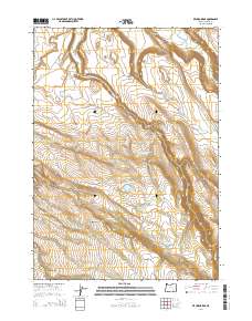
2014 Map of Krumbo Ridge
USGS Topo · Published 2014About this map
Krumbo Ridge and the volcanic heights of Krumbo Mtn dominate this high-desert portion of Harney County, Oregon. This landscape is defined by its complex water management for livestock and wildlife, featuring a network of named springs, seeps, and man-made reservoirs. Notable features like Ruby Springs, Antler Seep, and the Frazier Lake Waterhole indicate the critical importance of water sources in this arid environment. To the north, the terrain drops into Diamond Valley, where McCoy Cr and Cucamonga Cr channel seasonal flow through the draws. The geography is largely uninhabited, characterized by ranching infrastructure and remote landmarks such as the Moon Hill Lakebed and numerous irrigation points like Bird Fence Reservoir Number One. Secondary transit is limited to unpaved routes, specifically Moon Hill Rd and McCoy Creek Rd, which provide access to this isolated rimrock country.
Find a feature on this map
32 named features on this map. Tap any name to fly to it.
Don’t see what you’re looking for? This feature index may not catch every label — zoom into the map to look around manually.
Map Details
Editions of this 2014 Krumbo Ridge Map
This is the sole edition of this map. No revisions or reprints were ever made.
Other maps of this area

1955 · Burns
USGS Topo · 1:250,000

1955 · Adel
USGS Topo · 1:250,000

1957 · Adel
USGS Topo · 1:250,000

1958 · Burns
USGS Topo · 1:250,000

1958 · Adel
USGS Topo · 1:250,000

1959 · Burns
USGS Topo · 1:250,000

1962 · Adel
USGS Topo · 1:250,000

1967 · Happy Valley
USGS Topo · 1:24,000

1967 · Krumbo Reservoir
USGS Topo · 1:24,000
1967 · Diamond Swamp
USGS Topo · 1:24,000